Loire Valley, Rhône Valley, Vallée de la Marne, Mosel Valley, Barossa Valley, Hunter Valley, Douro Valley, Napa Valley, Russian River Valley, Willamette Valley, Hudson Valley, Yakima Valley…and so on. Wherever you go in the wine world, rivers are important elements when it comes to defining winegrowing regions.
Wine writers and marketers often refer to alluvial soils when telling the story of a particular vineyard site. These are, by definition, very diverse soils. As we consider the universe of alluvium, it’s clear that it encompasses a wide range of depositional circumstances, from a small mountain stream emptying onto a valley floor, to a massive river emptying into the ocean. Alluvial soils can thus have varying amount of gravel, clay, sand and silt.
Rivers around the wine world vary quite considerably in character, but they do share many common aspects regarding their formation and evolution. The genesis or rivers begins with the hydrologic cycle, which consists of three major processes: evaporation, condensation, and precipitation.
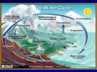
The Hydrologic Cycle Illustrated
Evaporation involves the physical changing of phase from a liquid state to a gaseous state. Energy, mostly from the sun but also from wind, provides the force for the change from water in the oceans or on land to water vapor. In its gaseous form, water can be transported onto land by wind.
Condensation is the reverse of evaporation in that the water vapor returns from its gaseous form to a liquid. We see evidence of condensation in cloud formation. Water vapor condenses around tiny nuclei and becomes visible as a cloud. Temperature and altitude can affect the condensation process because the atmosphere can hold less water as temperature decreases.
Precipitation describes water that falls to Earth in liquid or solid form as rain, snow or hail. Again, this results from changes in physical conditions like temperature that force the water vapor to condense to a point where it can no longer be suspended in the atmosphere.
As precipitation occurs on the earth’s land surface, water will initially sink into the soil but when the soil becomes saturated the excess water begins to flow down the slope and is incorporated into stream flow. Stream flow is defined as the flow of surface water between well-defined banks. The bits of soil disturbed by the rainfall are carried to the stream and become part of the sediment load of the watercourse. Natural springs can provide an additional streamflow source.
Regardless of the source, a stream channel will flow in the lowest places in the landscape. As smaller streams join together, the stream’s flow quantity and velocity increase. In the youthful, upper stages of a stream, slopes are steeper and it has the kinetic energy to erode its channel, creating a narrow V-shaped valley. Weathering and gravity cause material on the valley slopes to erode and perhaps fall into the fast-moving water which will transport sediments downstream. Think of the terraced vineyards of Còte Ròtie or the Douro Valley to visualize winegrowing in a young river profile.
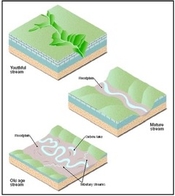
Stages of Stream Development
As the watercourse moves downstream, it accumulates water volume from tributaries and ground water. The slope of this mature stream stage decreases as does the velocity of the water flow. The carrying capacity is now reduced and the stream carries gravel, sand, silt and clay. With the increase in flow, the physical forces of fluid dynamics begin to change the character of the watercourse. Friction on the bottom and sides of a streambed slow the water flow and cause the water to form eddies and swirl around. Because of the friction, streams flow at variable speeds in a corkscrew, or helical fashion. The center flow in the deepest part of the stream can be twice as fast as the friction-slowed flow along the streambed. This natural rotation causes a stream to curve, or meander. It will erode its banks on the outward edge of the rotation, causing a curve in the watercourse. As water flows through the curve, it flows faster and with more erosive power on the outward edge. The flow on the inner edge is slower, and we find that rivers deposit sediment on the inner part of the curve. In times of flood, the water overflows the stream banks and deposits sediments that become the flood plain. Mature river profiles can be seen in the Willamette Valley of Oregon or the Rhein River in the Pfalz of Germany.
In its oldest stage, the flow rate slows down and the lower kinetic energy means that only finer particles like silt and clay are carried in the stream during normal flow. Over time and repeated flooding, old-stage streams erode their valleys laterally and expand the width of their flood plains. The curving form of the stream is enhanced, and looping meanders are common. The older stage of the stream usually terminates when it flows into a lake or ocean. The flow rate and carrying capacity is reduced so that all but the finest sediments drop, and a delta is formed. The Langhorne Creek area lies at the mouth of the Murray River in South Australia. The vineyards of the Médoc of Bordeaux are situated in an old-stage river environment.
The stages of stream development are easier to understand when thinking of a static environment. Reality, however, does not allow an undisturbed system. The land over which a river flows is not uniform, with relatively weak and resistant bedrocks that erode at different rates. A change in flow rate will upset the equilibrium. A river in flood stage has an entirely different dynamic than a quiet flow environment. Landmasses will rise and subside over geologic time which also alters the balance of a river profile.
Evidence of geologic uplift is found in the presence of fluvial terraces in many winegrowing areas. Fluvial terraces are the remnants of earlier floodplains of a river system that existed at a time when the river was flowing at a higher elevation. Terraces often provide an excellent habitat for grapevines, combining extra elevation with effective drainage for both air and water.
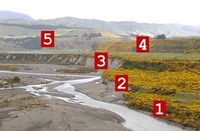
Five Terraces above the Awatere River of New Zealand
Fluvial terraces are elongated, generally flat-lying areas that flank the sides of river valleys. They consist of a relatively level strip of land, called a “tread,” separated from an adjacent terrace of floodplain by steeper slopes called “risers.” Terraces are composed of older floodplain sediments and are quite variable. Lenses of sand, gravel and clay can be found throughout the soils. Since a terrace is set above the too-wet river bottom, vigorous plants like grapevines can send their roots deep into the subsurface to find adequate moisture from clay deposits in the substrate while benefiting from the elevated perch and natural drainage. Vineyards of the southern Rhône are often on terraces above the river.
As we look at river systems and their natural processes, we know that the watercourses naturally move back and forth across their flood plains, depositing various lenses of sands, gravels, and clays as they go. A cross-section of an alluvial valley floor reveals an ever-changing sequence of various sediment sizes that can be very beneficial for grapevines, with the sands and gravels providing drainage and the clay lenses holding water that can be accessed by vine roots during periods of little or no rainfall.
Most of the Sauvignon Blancs from New Zealand’s Marlborough wine region come from vineyards in the Wairau Valley. Embedded in the gentle rises and swales of the valley floor are diverse alluvial sediments. Vintners know that grapes from gravelly sites yield different wines from those with larger fractions of clay. They can use that information to plan on a more complex final blend. On New Zealand’s North Island, the Gimblett Gravels district in Hawke’s Bay is situated on alluvial deposits of the Ngaruroro River. In Australia, the luscious ‘stickies’ of Rutherglen are drawn from alluvial soils of the Murray River.
River systems are infinitely variable and describing their soils as merely “alluvial” does little to define a particular vineyard site. Depending on geologic history, slope, proximity to upland areas, rainfall and other factors, alluvial soils can be any combination of sand, gravel, silt and clay. While a specific vineyard site may have properties influenced by a particular stream in that spot, that character will not likely be the same at a different site. It is one more aspect of the great diversity and unique quality of “terroir” as the French would call it.