Wine enthusiasts are quick to embrace the lexicon of geology when describing the provenance of their favorite wines. Throughout the wine world, we find references to the special limestone, granite, volcanic, schist, slate and other rocks that imbue wines with their special characteristics. This is a controversial point and often more than a bit overdone. The change in bedrock color or composition is the most visible of the many elements that create a beneficial site. There are clearly more important aspects, but it is always a combination of factors that coalesce to create a top vineyard. Geology is certainly important, but the broad impacts are sometimes overlooked when the focus is on the details.
Geology is not just the study of rocks and their derivative soils. The study of geology encompasses the natural forces that have created the diverse landforms (and undersea forms) of the earth. It requires an understanding not only of the forces that create and destroy the earth’s surface, but also of geologic time. The geologist must understand that these formidable powers are active every day but are rarely fully comprehended because they happen so slowly when compared to a human’s lifespan. The geologist is both a keen observer and an inquisitor — always asking “Why?” The study of geology informs not just the rocks underlying the vineyard slope, but why the slope is there at all. Which of nature’s powers combined to create the topography we observe today? If the soil is gravelly, how did the gravel get there? It’s not enough to know what is; we want to know why it is as well.

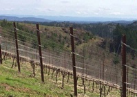
Steep Vineyard in the Yamhill-Carlton District of Oregon
It is obvious to all that differences inherent in vineyards render them superior or inferior. In many Old World areas, there are centuries of history and the best vineyards became evident over time. In the New World, however, there is no historic legacy that provides us with this knowledge. We must take a more calculated and informed approach if we wish to compress centuries of experience into an individual’s lifetime.
Grape growers know that specific sites consistently yield better or lesser quality fruit. The site differences may range from a few rows in a vineyard block to a sweet spot on a hillside, to a whole winegrowing region. Piecing together the complex puzzle of factors that result in superior vineyard sites enhances one’s understanding of the true meaning of terroir.
In a broad sense, geology plays a key role in determining the relative quality of a vineyard or winegrowing region. As a study of the forces that shape the earth, every specific site, vineyard or not, has a geologic story behind it. Consider the vineyards of Oregon — a winegrowing region with barely 50 years of modern winegrowing experience. We can define a number of geologic influences that allow exemplary wines to be made here.

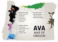
The AVAs of Oregon — Follow the Rivers
We know that the vineyards of Oregon are closely associated with river valleys around the state. The Willamette Valley is the most famous, but the Umpqua, Rogue, Applegate, Snake and Columbia are all important as well. The geologic forces that created the landscape of Oregon are, in many ways, responsible for the quality of its vineyards.
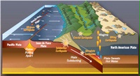
The Geologic story begins some 200 million years ago. The tectonic plates that form the Earth’s surface were and are in motion. The coast of the North American continent was near the Oregon-Idaho border of today, but the North American plate was moving westward. It began to collide with the Pacific plate. Rocks that comprise the continental crust are less dense than oceanic crust, so when plates collide, the denser oceanic crust is overridden by the lighter continental crust — a process called subduction. This process continues today. Oregon is on the leading edge of the North American plate that is overriding the oceanic plate at 3-4 centimeters per year. While that distance and pace is hardly recognizable when compared to a human lifespan, it is definitely significant from a geologic time perspective. That small incremental movement becomes 22 miles over a million years, 220 miles over ten million years.

Subduction on the West Coast of Oregon
As the subducted plate sinks deeper, it generates enough heat to melt the rock. As that molten rock rises, it is extruded in violent volcanic eruptions. These explosive eruptions first formed the ancestral Cascade Mountains — slightly west of the modern high Cascade peaks, and then the famous volcanoes we observe today. Mt. Rainier in Washington, Mt. Hood in Oregon and Mt. Shasta in California are the most famous peaks of the Cascade Range.
Even as subduction proceeded, sediments eroded off the emerging Oregon landmass were being deposited on the ocean floor. Some of these marine deposits were scraped off and pasted onto the continental land mass. Oregon has grown by this accretion process over the past 200 million years, adding some 350 miles of real estate stretching west from the Oregon-Idaho border of today. The accretion induced by subduction pushed up ridges near the coast – forming the Coast Range we see today.

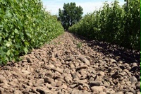
Basalt Flows of the Columbia Plateau
While the plates were colliding, another major event occurred around 16 million years ago. A series of volcanic vents opened up in eastern Oregon, near the Idaho border. In one of the largest volcanic events in the geologic record, a massive outpouring of basaltic lava continued for two million years with lava flows upon previous flows accumulating thousands of feet of volcanic rock. The basalt flows moved rapidly with some estimated to have flowed for 300 miles in a week’s time. The result we see today is the Columbia Plateau — a thick sequence of dark rocks that dominates eastern Oregon and Washington and has remnants in the Chehalem Mountains and Eola-Amity Hills of the Willamette Valley.
