Let’s start with a basic observation of the fluvial process. Imagine sitting beside a stream as a rainstorm begins. As you watch the drops strike the ground, you notice that loose soil splashes up around each individual impact. Perhaps the first raindrops sink into the soil but ultimately, the soil becomes saturated and the excess water begins to flow down the slope and is incorporated into stream flow. Stream flow is defined as the flow of surface water between well-defined banks. The bits of soil disturbed by the rainfall are carried to the stream and become part of the sediment load of the watercourse.
Stream flow is a more complex process that one might expect. Fluid flow, whether air or water, can move in laminar or turbulent flow regimes. Laminar flow moves in a straight line and is more rapid flow. Friction on the bottom and sides of a streambed slow the water flow and cause the water to form eddies and swirl around. This is known as turbulent flow. Because of the friction, streams flow at variable speeds in a corkscrew, or helical fashion. The center flow in the deepest part of the stream can be twice as fast as the friction-slowed flow along the streambed.

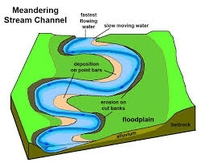
This natural rotation causes a stream to erode its banks on the outward edge of the rotation, causing a curve in the watercourse. As water flows through the curve, it flows faster and with more erosive power on the outward edge. The flow on the inner edge is slower, and we find that rivers deposit sediment on the inner part of the curve. Ultimately, the curves can erode themselves out of existence as they meet and form a cutoff, leaving the previous meander as an arcuate, oxbow lake. When we investigate the alluvial soils formed in this process, we will obviously find significant differences depending on the position of the former streambed.
Flowing water is a powerful medium for sediment transport. Consider the potential energy of a river. The Columbia River begins at an altitude of 2650 feet. A cubic foot of water weighs 62.4 pounds, so the potential energy is over 165,000 foot-pounds for every cubic foot. Compare that force to the one hundred foot-pounds needed to tighten the lug nuts on a car’s wheel. The Columbia discharges some 270,000 cubic feet of water per second into the Pacific Ocean, so a quick calculation shows over 44 billion foot pounds of potential energy. The potential energy at the headwaters is converted to kinetic energy as the water flows to the sea, but it’s clear that the power potential is immense.
We observe the power of water when rivers flood, particularly in urban areas where they cause the most destruction. Flooding is a natural part of all fluvial processes. Large depositional changes do not happen very much during times of quiet flow. They do occur during flooding, when the increased volume of water has tremendous potential to re-shape the landscape. Although major floods are once or twice in a lifetime occurrences on a human timescale, they are frequent and regular events in geologic time that are expected and inevitable.
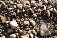
Wine writers often refer to alluvial soils when telling the story of a particular vineyard site. These are, by definition, very diverse soils. As we consider the universe of alluvium, it’s clear that it encompasses a wide range of depositional circumstances, from a small mountain stream emptying onto a valley floor, to a massive river emptying into the ocean. Alluvial soils can thus have varying amount of gravel, clay, sand and silt.

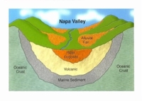
Rivers and streams often have their headwaters in mountainous or upland areas with steep slopes and end in relatively flat plains as they wind their way to a larger river or ultimately to an ocean or sea. They often flow into a broad valley where their gradient becomes more gradual. At these points of inflection, the carrying capacity of the water drops significantly and it can no longer carry the sediment that it is transporting. We observe the result as an alluvial fan, where the sediments spread out in a fan shape across the valley. There are several notable alluvial fans in the Napa Valley as well as in other California viticultural areas. The broad, fault-bounded valleys of California are similar to those of regions like Alsace and Burgundy in France in that the valleys have been filled with hundreds or even thousands of feet of alluvial sediments, washed into the lowlands as the bordering mountains rose.
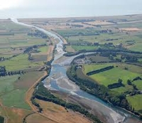
As we look at river systems and their natural processes, we know that the watercourses naturally move back and forth across their flood plains, depositing various lenses of sands, gravels, and clays as they go. A cross-section of an alluvial valley floor reveals an ever-changing sequence of various sediment sizes that can be very beneficial for grapevines, with the sands and gravels providing drainage and the clay lenses holding water that can be accessed by vine roots during periods of little or no rainfall.
Changes in sea levels as well as uplifts can offer alluvial soils in areas currently without much fluvial influence. The Russian River of northern California once flowed southward to San Pablo Bay. Tectonic forces caused uplift and changed the direction of the river to its current westward heading. The remnant sands and gravels of the previous course still provide well-drained vineyard sites. The southern Rhône River is noted as well for its alluvial terraces, now high above the river, that imbue the vineyards of Tavel, Lirac and the Côtes-du-Rhône-Villages appellation with their gravelly, well-drained character.
The vineyards situated in the Médoc of Bordeaux have been profoundly influenced by fluvial and alluvial forces. The famous gravel mounds of Margaux, Pauillac and neighboring villages were transported there by the Dordogne and Garonne Rivers, swollen by outpourings of glacial meltwaters. The vineyards of Cahors are set on sands and gravels deposited by the River Lot.

Most of the Sauvignon Blancs from New Zealand’s Marlborough wine region come from vineyards in the Wairau Valley. Embedded in the gentle rises and swales of the valley floor are diverse alluvial sediments. Vintners know that grapes from gravelly sites yield different wines from those with larger fractions of clay. They can use that information to plan on a more complex final blend. On New Zealand’s North Island, the Gimblett Gravels district in Hawke’s Bay is situated on alluvial deposits of the Ngaruroro River. In Australia, the luscious ‘stickies’ of Rutherglen are drawn from alluvial soils of the Murray River.

Old Vines on Alluvial Soils in Rutherglen
As you investigate wine growing regions and find references to vineyards with alluvial soil, you will know that those soils can take many forms. Depending on geologic history, slope, proximity to upland areas, rainfall and other factors, alluvial soils can be any combination of sand, gravel, silt and clay. While a specific vineyard site may have properties influenced by a particular stream in that spot, the fluvial influence is so variable that it is difficult to impose that set of characteristics on another alluvial area. It’s just another aspect of the great diversity and uniqueness of terroir.
