Geologists are map freaks. It comes with the territory. Part of one’s training in the field of geology will likely be drawing maps based on observations of the local geology. We can gain a great deal of information from a well-drawn geologic map regarding the history of the area detailed by the cartographer. As we transition to wine geeks, we bring our fascination for maps with us.
Pretty as they are…with their bright colors, geologic maps tend to be completely incomprehensible to the uninitiated. Seemingly random patterns and obscure abbreviations abound, and the maps are often quickly relegated back to the bookshelf or for use as an attractive wall hanging.
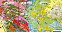
Figure 1: Geologic Map of the Loire Valley
The geologic underpinnings of many winegrowing areas are contorted and complex and truly require a great deal of study to fully comprehend. Let’s look at one aspect of the elements that are represented on a map and see how the odd graphic representation on the map is generated.
Keep in mind that a geologic map shows the information found on the earth’s surface. The study of geology is about discerning how this agglomeration of mountains, plains, rocks and soils came to be. I will use some simple drawings to illustrate a very simplistic geologic evolution.

Figure 2: Simple Uplift
Figure 2 represents an uplift. The tectonic forces that cause the uplift are a subject for another column, but they are powerful. Large earthquakes accompany these movements and the ground can rise several feet during an episode. For our purposes, let’s say a large body of granite is pushed up through existing layers of sedimentary rock represented by the various colors. This is a very simplistic view of what happens when mountain ranges are uplifted. The uplifting forces do, indeed, bend the intruded rock layers upward. The surface of the earth, however, is not a plastic medium, and hard rock formations do not bend as easily as depicted here. The various rock formations are brittle and tend to crack and break along planes of relative weakness, which become faults.

Figure 3: Faulted Uplift
Figure 3 offers a more complex rendition that reflects the cracking and faulting. As is evident in the drawing, slices of the earth’s crust have split away from each other as the mountain has risen. Note, however, that the various rock types are exposed in the same sequence within each imbrication of the bundle of faults.
Geology is a dynamic process, however, and the uplift, bending and faulting takes place over millions of years. During this time, there can be substantial erosion of the upper layers of rocks. Look now at the dark line through the faulted rock sequence and imagine that all the rocks above this level have been eroded away.

Figure 4: Faulted Uplift After Erosion
Figure 4 illustrates the eroded surface after the uplift. The upper layers of rock have all been worn away, leaving the layers that we see exposed on the surface. The sequence of rocks within the imbricated faults is still the same, but the pattern observed on the surface is quite variegated. The band at the bottom of the page demonstrates what a geologic map of the surface would show.
Keep in mind that this is a very simplified view of the process. The real world examples have far more variables. In Alsace we find an array of crisscrossed faults that have chopped the bedrock in two directions and created a massive 3-D geometric puzzle. Much of the reason for the famously varied soil types of Alsace lies in this complex fault bundle. The fault-bounded structure of Alsace continues northward into Germany, along the Rhine River valley.
Many other wine regions of France owe at least some of their distinction to the faulting that created their distinct positions. The course of the northern Rhône River has been altered by faulting and the vineyards of Côte Rôtie, Hermitage and Condrieu all benefit from their resultant exposures. In Burgundy, the famous Côte d’Or lies along the Saone fault zone, where there has been nearly a mile of vertical displacement between the slopes of Le Musigny and the RN74 highway on the valley floor. Only about ten percent of that movement is visible to the traveler since the down-dropped valley has been filled with alluvial sediments, but the vines show where the best ripening conditions are for fine wine. The vineyards of the Côte Chalonnais, Mâconnais, and Beaujolais are all shaped by the underlying geologic structure as well.
In the New World, many winegrowing areas are defined by faulted boundaries. California is a classic example, with Napa and Sonoma Counties rife with faults that dramatically affect the topography. Additionally, the vineyards of the Santa Lucia Highlands are perched above the Reliz Fault Zone in the Salinas Valley, with grapes mostly grown on the upthrown side and vegetables planted on the downthrown valley floor. Santa Barbara County is a geologist’s playground with its transverse mountain ranges and associated faulting.
The Marlborough region of New Zealand produces its distinctive Sauvignon Blancs in a broad valley that lies between the Wairau and Awatere Fault Zones. The coastal Casablanca Valley and Central Valley of Chile are defined by their faulted margins as well. In Australia, although the rocks are much older, the modern topography still follows the old fault traces in Victoria and South Australia.
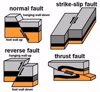
Figure 5: Types of Faults
We have only considered the simplest of faults in this mini-treatise. Figure 5 shows some of the more complex geometry of faults. If you mentally slice and dice these complicated forms, it’s easy to see how confounding the puzzle can be. Enjoy a glass of wine as you untangle the twists and turns of geologic mysteries.
