Terraces are the remnants of earlier floodplains of a river system that existed at a time when the river was flowing at a higher elevation. A river system naturally seeks an equilibrium status. At its source, a river normally has a steep gradient that becomes gentler as it reaches its base level – either when it flows into another river or into the sea. Without intervening forces, a river will ultimately achieve this profile. Reality, however, does not allow an undisturbed system. The land over which a river flows is not uniform. Relatively weak and resistant bedrocks will erode at different rates. A change in flow rate will upset the equilibrium. A river in flood stage has an entirely different dynamic than a quiet flow environment. Landmasses too will rise and subside over geologic time and alter the balance of a river profile.
One of the more geologically recent influences on river systems has been glaciation. At least four major advances of continental glaciers have occurred in the last two million years or so. When glaciers were at their maximum extent, much of the world’s water was locked in ice that was thousands of feet thick on the continents of the northern hemisphere. During these times, the sea level dropped 300-400 feet. This dramatically changed the equilibrium of river systems, allowing active channel cutting in the newly exposed land. When glacial retreats occurred, vast volumes of sediment poured out with the meltwaters, choking valleys with sediment burdens that rivers could not transport. Sea levels rose again with significant impacts on river profiles. We will explore how this fluvial geomorphology impact has affected vineyards in Arroyo Seco.
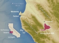
The Salinas Valley is an impressive place. The broad, flat valley floor is bounded by impressive mountains on both east and west. This is fertile and valuable agricultural land with a vast acreage of vegetable crops that feeds much of the nation with its bounty. It was recognized as a potential site for wine grapes in the early 1960’s when the Mirassou and Wente families established their first vineyards in what is now the Arroyo Seco AVA.

The underlying geology is important in understanding the distinctive nature of Arroyo Seco. The Santa Lucia Mountains began to rise around 8 million years ago, forced upward by the collision of the Pacific and North American tectonic plates. The Rinconada/Reliz fault zone parallels the San Andreas Fault and marks the eastern boundary of the uplift. Such uplifts are episodic, and there are quiet times interspersed with more active mountain building phases. When times were quiet, the rivers created broad valleys with wide flood plains. When uplift occurred, the greater potential energy allowed rivers to cut deeper, more narrow channels, leaving the previous plain as a terrace above the new river. The tectonic forces have combined with periodic sea level fluctuations during glacial advances and retreats over the past two million years to shape the basis for good vineyard sites.
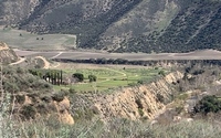
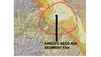
Today, the Santa Lucia Mountains rise as high as 5,000 feet and create a rain shadow for the Salinas Valley. The headwaters of the Arroyo Seco Creek are high in the mountains and the flow is contained in a steep and narrow channel until it crosses the fault line and enters the Salinas Valley. Here the valley is broad, with multiple terraces and gravelly soils resulting from previous river floodplains. The fan of sediments at the juncture with the Salinas Valley is clearly visible on a geologic map. For eleven miles, the creek flows to the Salinas River and ultimately to Monterey Bay. The cold waters off the coast provide a daily cooling influence as the marine air moves inland and lowers the temperatures in the vineyards. The wind pattern also allows air flow down the valley, keeping the air in motion and protecting against frost in the winter.

Geologic Map Showing the Fan of Sediment as the Creek Enters the Salinas Valley
There is a definite climate difference in Arroyo Seco. It is ranked as Region I and Region II on the UC Davis heat summation scale. The Salinas Valley floor is warmer and less compatible for cool climate grapes like Chardonnay and Pinot Noir. After the early Mirassou and Wente plantings, Jerry Lohr and Bill Jekel planted vineyards for their eponymous wineries in Arroyo Seco in the early 1970’s. They, with other pioneering Arroyo Seco winegrowers, submitted an AVA application with boundaries based on wind and water flow patterns as well as the distinctive soils. The AVA was approved in 1983, the fifteenth AVA in California, and it remains one of the smaller AVAs in the state at 18,240 acres. By comparison, the Napa Valley AVA encompasses 122,735 acres.

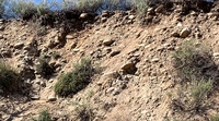
Alluvial Gravels and Cobbles that Form the Arroyo Seco Soils
There are currently around 8,000 acres planted to vines in the Arroyo Seco AVA. The cooling winds off Monterey Bay slow down the ripening process and allow longer hang time and flavor development in the grapes. If you visit the AVA, don’t expect to see a profusion of wineries and tasting rooms – you won’t find any. This is the land of the vine, not the winery. Most of the grapes harvested are transported to wineries in other locations. Some wineries as well, although they use Arroyo Seco fruit, prefer the more general Central Coast appellation.
The most common Arroyo Seco wines are the J. Lohr Riverstone Chardonnay and the Wente Vineyards Riva Ranch Chardonnay and Pinot Noir. Wineries like Bernardus, La Crema, Bonny Doon, Muirwood and Salamandre Cellars all use Arroyo Seco fruit to some degree. I find the Chardonnays typify a Monterey County style, with ripe tropical fruit, a buttery/butterscotch richness, a full texture and a decided lift at the finish. The prices for most wines are quite reasonable as well. Seek out an Arroyo Seco wine the next time you are shopping and start to explore this distinctive AVA.
